 Back in 1989 (I think) my best friends and I had the idea for a summer guy’s trip, It needed to be out there though – wild and away from others. Some place where we could be completely selfish, eat what we want, drink what we want, sleep when we want, etc, etc. Since that time, through weddings, the births of seven children, and various other life events we’ve only missed this trip one year. We started in the mountains outside of Missoula, Montana, then to the mountains close to Gunnison, CO and lately we’ve been going to Lake Powell in southern Utah. All of these areas are amazing in their own right but for me, Lake Powell is at the top of this very prestigious list :).
We’ve had many memorable adventures on Lake Powell. We always put in at Bullfrog Marina because it’s closest to our homes in northern Colorado. We’ve gone north all the way to the Colorado river and we’ve gone all the way south to the dam and Wahweap Marina (see my Antelope Canyon post). My favorite location is the Escalante. I love slot canyons, love ’em! Having them filled with water and slowly (carefully!) navigating through them on my friend’s ski boat is the pinnacle for me in a general sense and the Escalante is full of these amazing canyons. But honestly, anywhere you go on this magnificent lake will take your breath away.
The story I’m going to start with is from our 2009 trip. I’ll see how long this gets and then add to it if there’s room. This story is about our hike through West Canyon toward the southern end of the lake. We heard this was a moderately challenging 3-4 hours hike. As it turns out, it’s a moderately challenging hike for 20 year old young men who must also have a little Spiderman in them. Not quite the same for five middle-aged engineers, the youngest of whom was 42 and are just a tad past their prime athletic physiques of a couple  decades ago. We should have known something was amiss when we were told we needed to borrow a rope ladder – right there a loud alarm should have gone off.
The trip started off innocently enough. We all had very light breakfasts because A) we didn’t want to have full stomachs on a relatively strenuous hike and B) we <ahem> generally aren’t feeling much like eating in the mornings during our guys trips, ’nuff said. We filled our packs with some water, a few snacks and headed out. Driving the boat through West Canyon is awesome on it’s own. It’s a long winding canyon that gets pretty narrow by the end with very high walls. Once you anchor the boat as the canyon finally closes up, you start off wading through the water at the end to a pretty high sand berm that takes a little effort to get up and over. No problemo though for men like us. Then you have an awesome, leisurely stroll for about a mile through the first canyon. Along the way is a little stream with several pools filled with six – seven feet of water that are nice for cooling off but are unexpectedly frigid! I should mention here that there’s no way to avoid getting wet on this hike, so dress appropriately if you choose to see if I’m exaggerating any part of this for yourself :). The end of this phase of the hike comes at a point we called Mushroom Rock. Not sure if this a widely known  name or if it’s a local thing. At this point you can continue to the right along the canyon or you can climb up about a 12-foot high sheer drop if you can find a way up. Whichever path you choose, the other path is your exit – the trail from here is one big circuit back to this point. We chose to go right which is typical for most West Canyon hikers. In a brilliant bit of hiking strategy here, we decided that since we were an hour or so into the hike, we were only probably two hours from being back to this point so we decided to leave the pack filled with most of the water so we wouldn’t have to carry it all. Yeah, I know what you’re thinking…
The next section of the hike is AMAZING, at least it was for me. Imagine a water filled slot canyon (I tried to touch the bottom and never came close) that’s about four or five feet wide, twists and turns for about 100 yards and has canyon walls that jut straight up from the water for about 100 feet. It’s SOOO cool. I wish so much that we’d taken a waterproof camera for this part of the hike because it would be great to see this place again. So, we worked our way through this waterway, not really swimming, more like treading water in a certain direction because we were in no hurry to get through this part. A  dead scorpion floating on the water was an interesting sight along the way. After climbing out at the other end you start up for the first time right though the type of terrain that we’d all imagined for this hike – very narrow, sandstone-lined slot canyon. Beautiful.
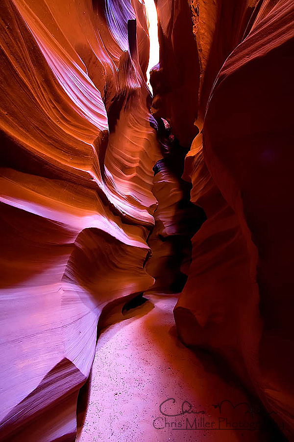
At this point, I need to describe what these slot canyons are like. Pretty narrow the entire way, walls that rose 50 – 100 feet or more straight up and filled with a multitude of small to very large boulders that have fallen from the tops of the canyons over the years. Many of the slots had “V” shaped floors as well which made walking tenuous through most of the hike.
This is how we spent the next two hours or so. Climbing up through these slots, using the rope ladder as needed three or four times as one or more of us found a particular boulder angled in such a way to make the climb beyond our abilities in one way or another. These were rarely high, most of the time six to eight feet or so but they bulged out in such a way that we couldn’t always get all five over the top without a little extra help. We were very glad we brought the rope ladder at these points. During this part of the hike we came to a wash out point where the trail widened. This is also one of the turn points that we had a description of but that description turned out to not match what we saw. The sun was brutally hot at this point and we wasted about 30 mins down the wrong path before getting reset up the correct slot. Could have been worse for sure.
 At this point, about three hours into the hike we didn’t feel like we were heading in the direction back to Mushroom Rock yet and we were starting to get thirsty and tired. One of the group had a quad muscle that was starting to spasm a bit as well so there was a little concern. We started to take a little more care with the water we had and all took a bit to eat something even though we didn’t have much with us. One other little nugget that was in our minds was the main reason we’d heard that we needed the rope ladder. A supposed 20-foot “cliff” that we’d have to get up at some point to continue along the path. While we’d heard it was 20 feet, the person describing it also said that it could be climbed without too much difficulty without a ladder but taking the ladder would be good just in case. No biggie, we can handle that, but we were a little anxious to see the problem and make sure we could handle it, especially now as we began to get a little winded. Injuries also started to worry us because a twisted/broken ankle/knee/back here was reasonably likely and would have been catastrophic being this far from the starting point of the hike and who knew how far to the end.
The one thing that kept us moving forward was how spectacular the environment was that we were traversing. So while I’ve said there was a little concern, no one was complaining because the hike was so amazing. So we continued on for another hour of this, using the rope ladder as needed a few more times but still climbing up. It was at this point that the trail ended in a great big sandstone bowl filled about 20% of the way up with three to eight foot diameter boulders, many of which were cracked and broken. Keep in mind that we still weren’t 100% confident that we had guessed right earlier at the washout. Now with the trail ending in the bowl we were seriously concerned. Were we even on the right path? At this point, one of our group noticed a tiny little water spillway chute *at least* 20 feet up at the top of the bowl. Could this possibly be the “20 foot, climbable cliff”? Really? How anyone could climb up there on their own seemed (and still seems) impossible to me. Yes, as it turns out, we were in the right place. The question in our minds though was: “now what do we do?” We were four hours or more from the start of the hike if we turned around now but we had no idea how to go forward. We talked about it and finally the biggest one of us walked to the wall, laid his hands against the wall and said  “Chris, crawl up on my shoulders and see if you can get up”. My first thought was “So you still have some of last night’s beer working through your veins I see”, but he was serious. I could tell there was no way this would get me to the top. At about 15 feet, the wall rounded a tiny little bit so at some point before the very top, one could possibly find some purchase and climb the rest of the way. I knew there was no way this would work but he was adamant so I figured I’d climb up there and at least see if I could figure out some alternative. With help from the other guys, I climbed my friend (also named Chris) and found just what I thought. I wasn’t even close and now, looking down I saw the bowl of sharp, broken boulders that was my landing area if I fell or if the other Chris found he couldn’t hold me anymore. Peachy. Then the second brilliant idea pops out of the “crowd’ at the bottom. “Dave, crawl up on Chris’s shoulders and see if you can make it”. “Ha, ha, very freakin’ funny” I thought, eyes growing wide as the other two guys started helping Dave crawl up the other (bottom) Chris. This is how I know there’s a God and it just wasn’t my time to go that day. Dave actually made it
  up onto my shoulders believe it or not, and somehow the bottom Chris didn’t seem to be in bad shape with now around 400 pounds on his shoulders (he’s a MONSTER!!). The bad news is that Dave still couldn’t find enough purchase to make it the final distance. He was angled a little bit though so I had him get on my hands and I pushed him as high as I possibly could get him, even angling my fingers to get that last fraction of an inch. The bottom Chris was also straining to be as tall as he could be. Dave was saying “no, no, no I can’t make it….” and then I felt one foot lift off my shoulders. He stayed like this for a few seconds as a test and then slowly and carefully inched the rest of his body a little further up. If he’d fallen, at least two of us and probably more would have been seriously injured and a LONG way from help. After gaining a little confidence though, he s-l-o-w-l-y edged the other foot off my shoulders. It still was touch and go and everyone was quiet as inch by inch
  to keep from sliding back down, Dave slowly got to the point where he could finally get to his knees and then to his feet at the top.
At this point we all almost exploded. We were so pumped and full of ourselves. But the bottom Chris brought us back to earth after a while noting that his shoulders were starting to hurt since I, of course, was still standing on them. We handed up the rope ladder with me having to toss it the last 10 feet or so to Dave. He caught it, anchored it well and then held on while I climbed up. We then teamed up to get the rest of the guys to the top and had another manliness party at the top. The only thing better would have been if we’d had Flight of the Valkyries or something playing through that canyon while we owned this trivial hurdle (yeah, right :)). All our fatigue and worry had undergone an adrenaline beat-down so we started up the next slot eager and ready to work.
The next obstacle for us was the second and final turn point. Again, we had a description of what the turn looked like but it turned out to not be the image we had in our heads. We missed it again and this time we lost probably an hour or more heading up another slot canyon instead of finally exiting and heading back down towards the boat. We all had the sinking feeling that we were heading in the wrong direction again though so we turned around, climbed a small hill and we were out of the canyon. Our view at this point , while we were drinking the last of our water, was high above the lake looking down on what could have been West Canyon but could have been another arm as well. At least it was down though, and towards the water so we decided to go for it. It “felt” better to all of us although I was still worried. The climb down was as treacherous as the climb up and there were a couple places where all of us wondered how we were going to get down through what we saw. Luckily there was always a pathway, we just had to find it and take it slow. On one occasion we had to slide down under a 5-ton boulder that had fallen and landed atop two other boulders creating a 4-foot wide by 2-foot tall chute that angled down pretty severely. We used the rope ladder to inch down through the “tunnel” on our backs, the last person (me) getting assistance from the others since I couldn’t use the ladder. After  working our way down through several similar hurdles the terrain flattened out into more of a sand plateau. We continued forward a short distance and finally after approximately 6 or so hours after leaving Mushroom Rock (and our pack with water and snacks) we arrived at the top of the 12-foot high drop which was much easier to get down that we imagined it would be getting up our first time through. Our first order of business was to rehydrate of course and have something to eat since we hadn’t really eaten much that entire day that was now getting close to night.
There were still a few other roadblocks to navigate on the way out. A 3-4 hour hike had turned into an eight hour excursion for us but we’d made it, tired and still hungry for some real food but knowing that we’d remember this hike for the rest our lives. Thanks much for reading about it.
If you liked the story, I think you’ll like taking a few more minutes to check out the rest of the images in the Lake Powell gallery.


 wed then that if we ever convinced ourselves to try this again, I’d definitely take a camera. I wasn’t able to take my Canon 7D but I was able to take our point and shoot which takes pretty nice pictures for a small camera. I had it in a waterproof case to protect it from the water and other hazards on that will soon become obvious.


 narrows to form a “V” at the bottom which makes the hiking a little tougher here (yeah, this is the case in the picture on the right).


